Elora Cataract Trailway: Forks of the Credit to Elora
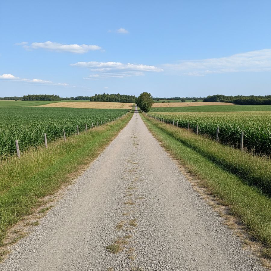
The Elora Cataract Trailway is one of Ontario's longer rail trails and one of the most rewarding. Running roughly 47 kilometres from the Forks of the Credit area near Cataract west to the village of Elora, it crosses through some of the best countryside in Dufferin and Wellington counties. This is not a waterfront path or an urban multi-use trail. It is a proper backcountry rail trail through agricultural heartland, with rolling hills, creek crossings, and small towns where you can stop for food and water. The surface is crushed gravel, mostly well-packed but occasionally loose, and the route has more elevation change than typical rail trails thanks to the terrain it crosses.
Route Details
- Distance: 47 km one way
- Surface: Crushed gravel
- Difficulty: Moderate / rolling hills
- Family-Friendly: Sections near towns; full trail better for older kids
- Best Season: May through October
- Parking: Trailheads at Cataract, Erin, Hillsburgh, Fergus, and Elora
The Route
The eastern terminus is near the hamlet of Cataract, close to the Forks of the Credit Provincial Park. This is where the Credit River carves through the Niagara Escarpment, and the landscape is dramatic by southern Ontario standards. The trail begins at a higher elevation here and gradually trends downhill as you head west, though "gradually" understates the rolling character of the middle sections.
From Cataract, the trail heads west through Alton and on toward Erin, about 15 kilometres in. Erin is a small town with a general store, a few restaurants, and a park near the trail. It makes a reasonable first stop. The section between Cataract and Erin is one of the more scenic portions, passing through forests and along the edges of river valleys. The gravel surface here can be loose in spots, especially after dry spells when the fines blow away.
West of Erin, the trail continues through Hillsburgh and into the more open farmland of Wellington County. The scenery shifts from wooded valleys to wide fields of grain and hay, with big skies and long views. Shelburne is accessible via a short road detour north of the trail, though it is not directly on the route. The terrain through this section is gently rolling, with enough ups and downs to keep your legs honest without being punishing.
Fergus, about 37 kilometres from Cataract, is the second-to-last significant town before Elora. It sits on the Grand River and has a proper downtown with shops, restaurants, and services. If you started in Cataract, Fergus is where most riders take their main break. The trail runs along the river for a stretch here, and the views are worth slowing down for.
The final 10 kilometres from Fergus to Elora follow the Grand River valley. Elora itself is a destination town, known for the Elora Gorge and its limestone architecture. The gorge is dramatic, with sheer limestone walls dropping to the river below. The trail ends near the town's centre, putting you within walking distance of restaurants, galleries, and the gorge lookout. It is a satisfying finish to a long ride.
Surface and Bike Choice
Crushed gravel is the surface for the full distance. The quality varies. Sections near towns tend to be well-graded and firmly packed. More remote stretches can be loose, sandy, or rutted, especially in the early season before maintenance crews have had a chance to grade the surface. A gravel bike is the ideal choice here. Mountain bikes work fine but are slower than necessary for most of the trail. Hybrid bikes with tires of 35mm or wider will handle the majority of the route, though you may need to walk short sections if conditions are rough.
Road bikes are not suitable for this trail. Even in perfect conditions, the surface is too loose for tires under 32mm, and you will spend more time managing traction than enjoying the ride.
Difficulty and Fitness
This is a moderate trail, not a beginner ride. The 47-kilometre one-way distance is significant, and if you are doing it as an out-and-back, you are looking at 94 kilometres of gravel riding. The rolling terrain adds to the effort. Individual hills are short, rarely more than a few hundred metres, but they accumulate over the full distance.
Most reasonably fit riders can complete the one-way route in three to four hours, plus stops. If you are planning an out-and-back, budget a full day. Alternatively, arrange a shuttle or have someone drop you at one end and pick you up at the other. Elora to Cataract is the slightly easier direction since you gain a net elevation heading east, though the rolling terrain means you will still climb.
For families, the sections near Erin and Fergus work as shorter out-and-back rides. The full trail is better suited to teenagers and adults with some riding experience.
What Makes It Worth the Effort
The Elora Cataract Trailway offers something that most Ontario rail trails do not: genuine variety. Over 47 kilometres, you move through forest, river valleys, open farmland, and small towns. The elevation changes give the ride a rhythm that flat trails lack. And the endpoints are both genuinely interesting places to visit, not just parking lots.
This trail also feels remote in a way that is hard to find close to the Greater Toronto Area. Cataract is only about 90 minutes from downtown Toronto, but once you are on the trail, the suburban sprawl disappears completely. You are in farm country, riding through landscapes that have not changed much in decades.
Practical Details
The Cataract trailhead is accessible from Highway 10 south of Orangeville. Elora is reachable via Highway 6 north of Guelph. Both trailheads have free parking. Intermediate trailheads at Erin, Hillsburgh, and Fergus allow you to ride shorter sections if you prefer.
Water and washroom availability is limited between towns. Carry at least one full bottle per 15 kilometres of riding, more on hot days. The towns along the route all have restaurants and convenience stores where you can refill.
The trail is busiest on summer weekends, particularly the sections near Elora and Erin. Weekday rides are noticeably quieter. Early morning starts on weekends also help you beat the crowds.
For trail conditions and maintenance schedules, check the Ontario Trails Council website. The trail is managed by multiple municipalities, so conditions can vary by section. Local cycling groups in Guelph and Orangeville are good sources for current reports during the riding season.
If you are looking to combine this trail with other rides in the area, the eastern Ontario cycling guide covers more options in the surrounding counties. The best rail trails in Ontario roundup also includes the Elora Cataract Trailway alongside other top picks.