Cycling in Petawawa
Petawawa is not the first town people think of for cycling in Ontario, which is part of what makes it worth the trip. Sitting where the Petawawa River meets the Ottawa River, with Canadian Forces Base Petawawa occupying a large part of the surrounding land, the town has a surprising amount of trail infrastructure. The military base has developed an extensive network of paved and gravel paths over the years, some of which are open to public use. Add in the Ottawa River Pathway running through the area and quiet valley roads heading in every direction, and you have a solid cycling base that most Ontario riders overlook.
Nearby Trails and Paths
The Ottawa River Pathway is the main paved route in the area. It follows the river through Petawawa and connects to the broader pathway network that stretches toward Pembroke. The surface is paved and well maintained, the grade is flat along the river corridor, and the views of the Ottawa River are constant. You can ride out and back for whatever distance suits you, or connect to the Algonquin Trail further east.
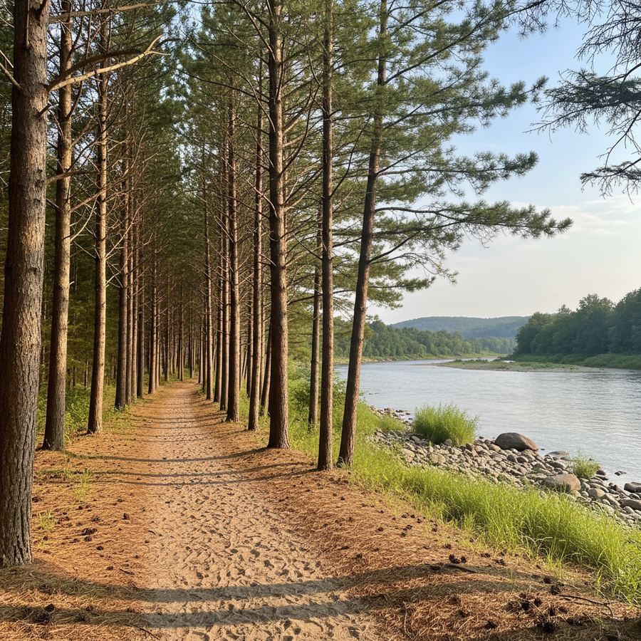
The Petawawa River trails run along the river's banks through town and into the surrounding forest. These are mostly packed gravel and natural surface, suitable for mountain bikes and sturdy hybrids. The trails pass through stands of white pine and mixed forest, and you will often see the river through the trees. The town's trail map is available at the municipal office and online.
Some sections of the CFB Petawawa trail network are accessible to the public, particularly the paved paths along Petawawa Boulevard and the perimeter areas. Check current access rules before riding, as military operations can close sections without notice. The paved sections that are open are excellent: wide, smooth, and virtually traffic-free.
In-Town Riding
Petawawa is a spread-out town, which means there is space between things but also means the roads are wide and traffic is manageable. Petawawa Boulevard is the main east-west corridor and has paved shoulders for most of its length. Murphy Road and Doran Road connect the residential areas to the trails and the river.
The Petawawa Point area, where the two rivers meet, is the scenic highlight. You can ride out to the point on a combination of paved path and quiet residential streets. Bring a lock and walk down to the water, where the Petawawa River flows into the Ottawa. It is a good spot to rest and refill water bottles.
Family-Friendly Options
The Ottawa River Pathway is the best family ride in the area. It is flat, paved, and separated from vehicle traffic. You can ride as far as the kids want and turn around, with benches and rest spots along the way. The section through town passes parks with playgrounds and washroom facilities.
The trails along the Petawawa River are suitable for older kids who are comfortable on gravel. The grades are minimal and the forest setting keeps things cool on hot days. For more family-friendly rides across the province, our guide covers options at every skill level.
Algonquin Provincial Park is about 45 minutes west by car. While the park itself is not a cycling destination in the traditional sense, the Highway 60 corridor has wide shoulders and some of the most dramatic scenery in Ontario. Older teens and confident riders can handle the rolling terrain, and the park entrance area has short trails worth exploring on two wheels.
Downtown Stops
Petawawa's commercial area is along Petawawa Boulevard and Murphy Road. It is more strip-mall than historic downtown, but there are good restaurants and coffee shops scattered through the area. The Tim Hortons on Petawawa Boulevard is the unofficial gathering spot, but there are independent options too.
Pembroke, about 15 minutes east, has a more traditional downtown with cafes, restaurants, and shops along Pembroke Street. If you are spending a few days in the area, Pembroke is worth a visit for a meal or a walk along the Ottawa River waterfront there.
Best Season
The riding season runs from mid-May through October. Spring comes a bit later here than in southern Ontario, and the trails along the rivers can stay wet into early June in a rainy year. Summer is warm and the long daylight hours in the Ottawa Valley give you plenty of riding time. Blackflies and mosquitoes are real in June and early July, so bring repellent or plan rides for open, breezy sections of the pathway.
September is arguably the best month. The bugs are gone, the heat breaks, and the mixed forests along the Petawawa River start turning colour. The Ottawa River Pathway in fall is a quiet, beautiful ride.
Nearby Combos
Petawawa is a natural base for exploring the Ottawa Valley cycling region. From here you can ride the Ottawa River Pathway east toward Pembroke or drive to trailheads further along the valley. The valley roads heading south toward Eganville and the Bonnechere River are rolling and scenic, suited to road bikes and gravel setups alike.
For a multi-day trip, combine Petawawa with a visit to Algonquin Park and then ride the valley roads south. The terrain is hillier than most of southern Ontario, but the scenery and the quiet roads make up for the extra effort. This part of the province sees far fewer cyclists than the popular southern trails, so you will often have the road to yourself.
Planning More Time in Petawawa?
Petawawa's location at the meeting of two rivers, near Algonquin Park, makes it a good base for more than just cycling. Fishing, paddling, and hiking are all accessible from town. For a broader look at the community, see the local guide to Petawawa.