Muskoka-Almaguin Cycling: Cottage Country Rides & Fall Colour Routes
Muskoka and the Almaguin Highlands form the heart of Ontario's cottage country, a landscape defined by Canadian Shield rock, deep lakes, pine and hardwood forest, and winding roads that seem purpose-built for cycling. The terrain here is more demanding than the flat farmland further south, but the payoff is constant: lake views around every bend, quiet roads through old-growth forest, and towns that have been welcoming visitors for over a century. For autumn cyclists, this region delivers some of the most vivid fall colour in the province.
Key Towns
Bracebridge
Bracebridge sits at the geographic centre of Muskoka, straddling the Muskoka River where it drops over a series of falls. The town's main street has a good selection of restaurants and shops, and the surrounding road network offers rides ranging from easy lakeside spins to tough hill routes through the shield. Bracebridge is the most practical base for exploring the southern half of the Muskoka cycling territory, with accommodation options at every price point and a welcoming attitude toward outdoor recreation.
Gravenhurst
Gravenhurst is the southern gateway to Muskoka, sitting at the foot of Lake Muskoka. The town's waterfront area is well-developed with paths and parks. Roads heading north from Gravenhurst toward Bracebridge follow the lakeshore through a mix of residential areas and forest. The terrain is moderately hilly, with the Canadian Shield creating a constant pattern of short climbs and descents. Gravenhurst connects directly to the Highway 11 corridor and is accessible by Ontario Northland bus service from Toronto.
Huntsville
Huntsville occupies a narrow isthmus between two lakes in northern Muskoka. The town has a thriving arts and food scene that rivals communities twice its size. For cyclists, Huntsville offers access to the roads around Algonquin Park's western corridor, where the terrain becomes wilder and the traffic thins out. The town's trail system includes paved multi-use paths along the waterfront and connections to longer routes heading into the surrounding forest.
Burk's Falls and Sundridge
Burk's Falls marks the transition from Muskoka into the Almaguin Highlands. This small town on the Magnetawan River offers basic services and a quieter atmosphere than the Muskoka resort towns further south. The riding north of Burk's Falls enters increasingly remote territory, with long stretches of forest road and very little traffic. Sundridge, a few kilometres north on the shores of Bernard Lake, provides another small-town base for exploring the highlands. Together, these towns open up a cycling landscape that feels genuinely wild and unspoiled.
Cottage Country Riding
The character of cycling in Muskoka and Almaguin is shaped by the Canadian Shield. Roads here do not follow straight concession lines like they do in the flat agricultural counties to the south. Instead, they curve around lakes, climb over granite ridges, and dip through valleys carved by ancient glaciers. This makes for engaging, varied riding where the scenery changes constantly, but it also means that flat stretches are rare and accumulated elevation gain builds up faster than you might expect.
The best cycling roads are the secondary highways and township roads that connect lakeside communities. Routes along Muskoka Road 118 (east and west from Bracebridge), Highway 141 to Rosseau, and the back roads around Lake of Bays near Huntsville all offer excellent riding with manageable traffic. The key is to avoid Highway 11, which carries heavy traffic and has no cycling infrastructure.
Many of the most scenic rides in Ontario can be found on these Muskoka back roads, where the combination of water, rock, and forest creates a landscape that shifts with every kilometre.
Terrain
Expect rolling to hilly terrain throughout. The southern parts of Muskoka around Gravenhurst and Bracebridge feature moderate hills with climbs of 30 to 60 metres. Further north around Huntsville and into the Almaguin Highlands, the terrain becomes more pronounced, with longer climbs and steeper grades. None of the climbs are alpine-scale, but the constant up and down adds significant work to any ride longer than 50 kilometres.
Road surfaces are generally good on the main routes. Township roads vary, and some may have rough patches or loose gravel shoulders. Wider tires (28mm or more) provide a comfort advantage on the rougher roads. The region's trail options are more limited than areas like Georgian Bay, with fewer dedicated rail trails. Most cycling here happens on the roads.
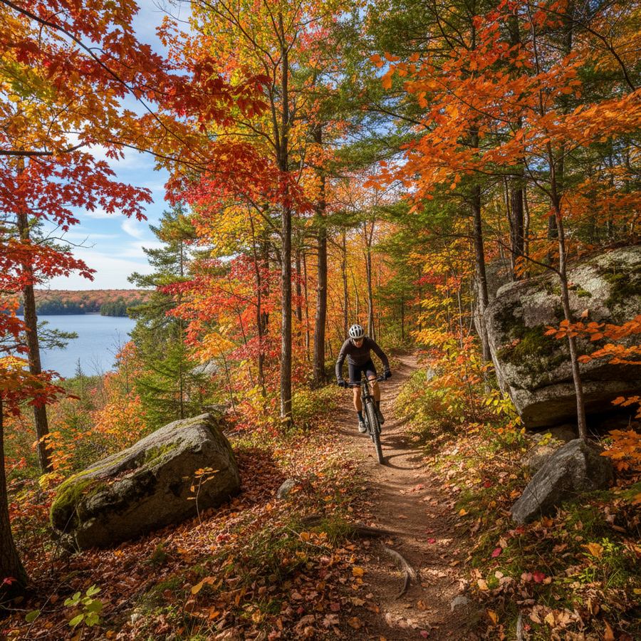
Fall Colours
Muskoka is one of the premier fall colour destinations in eastern North America, and experiencing it from a bike is incomparably better than from a car. The peak colour period typically runs from late September through mid-October, varying by a week or two depending on the year. The hardwood forests, predominantly sugar maple, red maple, and birch, produce intense reds, oranges, and golds that contrast with the dark green of white pine and spruce. The Muskoka Tourism website publishes fall colour reports during the season.
Riding during peak colour means cooler temperatures (daytime highs of 10 to 15 degrees Celsius), shorter days, and the possibility of rain. Bring layers, arm warmers, and a rain jacket. The trade-off is riding through some of the most beautiful scenery Ontario has to offer, on roads that are far emptier than during the summer cottage rush.
Best Seasons and Planning
June through October covers the full season. Summer (July and August) brings warm temperatures and the longest days, but also the heaviest cottage traffic on Friday evenings and Sunday afternoons. Weekday riding in summer is excellent. September and October are the prime months for serious cycling, combining comfortable temperatures, reduced traffic, and spectacular natural beauty.
Services in the main towns are comprehensive, but the gaps between communities can be long. The stretch from Huntsville north to Burk's Falls covers roughly 50 kilometres with minimal services in between. Plan your supplies accordingly, and carry more water than you think you need on hot days. Cell service is unreliable on many of the back roads, particularly in the Almaguin Highlands. A physical map or downloaded GPS route is essential equipment for exploring beyond the main highways.